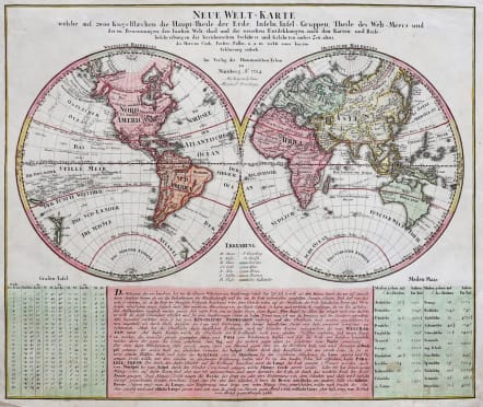
NEUE WELT- KARTE
Sold
This very attractive and interesting world map presents some curious cartography, given the date of the map. The Great Lakes are shown as one huge body of water and California is strangely shaped with the Baja nearly appearing as an island. Australia includes several place names on the eastern coast, which resulted from Cook's discoveries in 1770. However, Van Diemens Land is still shown connected to the mainland. An early World map to locate Hawaii, the map includes the tracks of Goree's voyate in 1780, Clerke's Voyage in 1779 and Cook's voyage in 1777-78. Colour key german text panel below the hemispheres.
Strong excellent hand colour.
Very good condition.
code : M3065
Cartographer : Homann Family
Date : 1784 Nuremberg
Size : 47.5*57cms
availability : Sold
Price : Sold
Johann Baptist Homann (1664-1724) started his career in Amsterdam as an apprentice with the Danckerts family before returning to Nuremberg to establish himself in business in 1702.
The firm quickly became the principal geographical publishers in Germany and in 1715 Homann was appointed Geographer to the Holy Roman Emperor and he was also a member of the Prussian Royal Academy of Sciences.
His publications included the "Neuer Atlas Ueber Die Gantze Welt ..." in 1707-. The "Grosser Atlas ..." of 1716- and the "Atlas Novus Terrarum Orbis Imperioa" in c.1720, as well as many others. Johann died in 1724 and was succeeded by his son Johann Christoph who died in 1730. After his death the firm took the name Homann's Heirs and continued thereafter until 1813. Publications with the Homann's Heirs' imprint included the "Grosser Atlas" in 1731, Doppelmays'r "Atlas Coelestis ..." in 1742 and the "Atlas Geographicus Maior ..." in 1753-, amongst others. Throughout this entire period the firm were the leading map publishers in Germany, employing a number of very important cartographers