

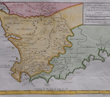

LE PAYS DES HOTTENTOTS AUX ENVIRONS DU CAP DE BONNE ESPERANCE
£85
Attractive and detailed map of Cape Colony, from Baye de St. Helen and Baye Saldane in the west to Baye de Musssel in the East, centered on the Dutch Hottentot regions and Petit Cafres. Shows tribes, rivers, towns, mountains, lakes, bays, capes, and a host of other details.
Of interest is the abandoned French colony at Saldhana Bay.
From Abbé Prevost's 'Histoire Generale des Voyages'
Good hand colour
Very good condition
code : M5005
Cartographer : Jacques-Nicolas BELLIN
Date : 1757 Paris
Size : 25*35 cms
availability : Available
Price : £85
Jacques-Nicolas Bellin (1703-1772) was one of the most important and prolific French cartographers of the mid-eighteenth century, in the service of the French Hydrographical Office. He was appointed the first Ingenieur Hydrographe de la Marine, and also Official Hydrographer to the French King.
Bellin was responsible for an enormous output of charts and maps. In a large folio format, he issued a volume of sea-charts of France, the Neptune Francois, and several sea-atlases of the World, including the Atlas Maritime and the Hydrographie Francaise. These large charts were amongst the best of the period and continued being reissued throughout the second half of the eighteenth century.
In smaller format, he issued the Petit Atlas Maritime (1764),which contained 580 detailed charts, as well as maps to illustrate l'Abbe Prevost's Histoire Generale des Voyages (1746-1757). Bellin also produced a substantial number of important separately issued maps, particularly reflecting continuing discoveries and political events in the Americas.


