
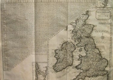
BRITISH ISLES
£50
Interesting and uncommon map of the British Isles with the distances 'of the cities and shire towns in England & Wales'.Compass rose.Repair on back invisible, otherwise good conditions.
code : M2430
Cartographer : STOCKDALE John
Date : 1805 London
Size : 37*48cms
availability : Available
Price : £50
John Stockdale (March 25, 1750 - June 21, 1814) was an English book and map publisher active in London in the late 18th and early 19th centuries.
Stockdale had a number of important works to his name, including several geographies, most notably the 1794 American Geography 1794 and, with John Cary, the 1805 New British Atlas
British Isles

Italy

£125
Italy

West Indies