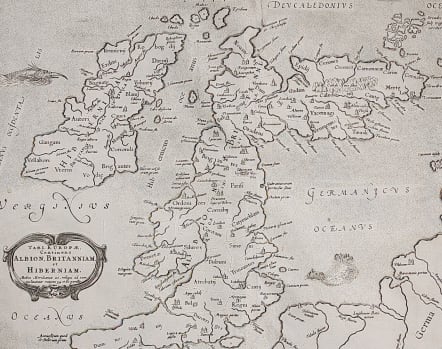
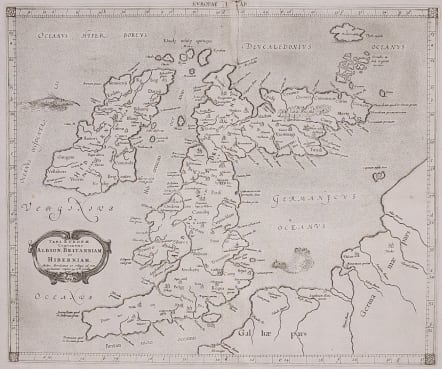
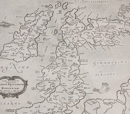
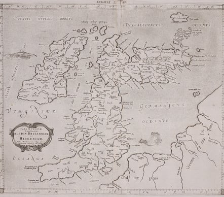
BRITISH ISLES TAB 1 EUROPAE CONTINENS ALBION BRITANNIAM ET HINERNIAM
Sold
This fine Ptolemaic map of the British Isles shows ancient place names and divisions. Scotland is shown with its distinctive east-west orientation. The map is decorated with a strapwork title cartouche, sea monster and a fishing scene in the North Sea. Mercator originally published this map in his 1578 edition of Ptolemy's great Geography; this is from the last edition and a crack in the plate at top is evident in this example. Although he is most renowned today for the projection he popularized and for first using the term 'atlas' for a collection of maps, he devoted much of his life to his Ptolemaic maps. The maps were beautifully engraved as nearly as possible to their original form and decorated with strapwork cartouches and interesting vignettes reflecting the customs of the region. Small crack in plate for this later printing.
Uncoloured as issued
Very good condition
Publication: Claudii Ptolemaei's Atlas Tabulae geographicae Orbis Terrarum
Ref: Mickwitz & Miekkavaara, (Nordenskiold-2) #235-19.
code : M3704
Cartographer : GERARD MERCATOR
Date : 1578/ 1698
Size : 40.5 x 33. cm
availability : Sold
Price : Sold
Gerard MERCATOR
Originally a student of philosophy Gerard Mercator (1512-1594). He became an expert in land surveying and cartography, as well as a skilled engraver.His first maps were published in 1537 (Palestine), and 1538 (a map of the world), although his main occupation at this time was globe-making. He later moved to Duisburg, in Germany, where he produced his outstanding wall maps of Europe and of Britain. In 1569 he published his masterpiece, the twenty-one-sheet map of the world, constructed on what is now known as Mercator's projection.
It was during this period, while teaching cosmography at Duisburg, that Mercator realised the pressing need for a modern collection of maps to supersede the Ptolemaic atlases. This project was gradually expanded to be a complete description of the Universe, both heaven and earth, with other volumes on the Creation, Genealogy and History and a Chronology. The description of the earth was to be in two parts, a modern geography and a Ptolemaic atlas, a massive and over-ambitious project. In fact, only the Chronology and the Ptolemaic Geographia were completed in his lifetime, and it was left to his son, Rumold, to complete and publish the world atlas in 1595. Entitled Atlas, sive Cosmographicae Meditationes de Fabrica Mundi, this was the first time the name "Atlas" was applied to a bound collection of maps, and, like Mercator's projection, has remained in everyday use to this day.
After Rumold's death in 1599, the plates for the atlas were published by Gerard Jr. Following his death in 1604, the printing stock was bought at auction by Jodocus Hondius, and re-issued well into the seventeenth century.
The Atlas Minor was reprinted,reengraved by many 16th century Dutch cartographers including Cloppenberg, Jansson etc.