MONDO NUOVO
Sold
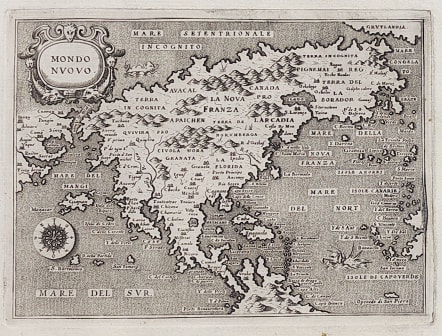
Rare early map of North America. The second seperate printed map of North America after Forlani's map of 1565, on which this map is pretty much based.
North America (Mondo Nuovo), from Porcacchi's L`Isole piu Famose del Mondo, Venice. ) This is the first state of this charming copper engraved map of the continent based on the Paolo Forlani map. The continent depicts the vastly elongated extension of the eastern seaboard, the Strait of Anian, a rather odd bulge in the California peninsula and Giapan (Japan) just offshore. Only the second map to name the Annan Straights Streto di Anian, Japan , Giapan, not far from californian coast. Lago, in the north east shows some early knowledge of inland lakes..the Great Lakes..
Copperplate engraving executed by Girolamo Porro of Padua, with the map centered in a page of Italian text. Good strong impression from early printing.
Uncoloured as always issued.
Slight printers crease in right margin
Very good condition
code : M4578
Cartographer : MAGINI Giovanni
Date : 1575 Venice
Size : 14.5*10.5 cms page 29*20 cms
availability : Sold
Price : Sold
Giovanni Antonio Magini (1555-1617) was born in Padua, Italy, and studied medicine, mathematics, astronomy and philosophy at the University of Bologna where he was later to become a professor of astronomy. He corresponded with many of the renowned figures of the age including Ortelius, Tycho Brahe, Galileo and Johanes Kepler. He authored various works on astronomy and also produced the first printed atlas of Italy, which was published posthumously by his son Fabio. Other works included the "Geographiae Universiae" (1597) and "Moderne Tavole Di Geografia" amongst others.