LOUISIANA TEXAS CARTE DE LA FLORIDE,DE LA LOUISIANE ET PAYS VOISINS
Sold
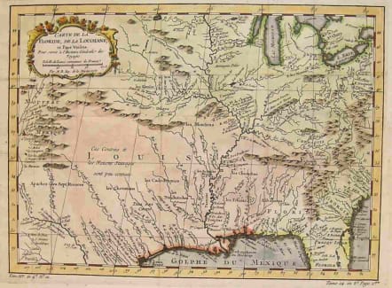
Attractive map of old Louisiana and northern and western Florida showing the French claims west of the Appalachians. Map covers an area from Lakes Michigan and Erie south to the Gulf Coast including the South Carolina and Georgia coastline. A large Louisiana stretches westward and northward to New Mexico with many Indian lands noted and some areas as "unknown." The Mississippi River runs southward to the Gulf; and map shows the Texas coast to San Luis Pass below Galveston and names Natchez, New Orleans, Biloxi, Mobile Bay and Pensacola and the northwestern Florida coast, showing St. Augustine & Cape Canaveral on the east coast. Map has very decorative title cartouche of leaf, flower and scroll motif.Excellent full hand colour.Very good condition.
code : M1516
Cartographer : Jacques-Nicolas BELLIN
Date : 1757 Paris
Size : 22.5*31cms
availability : Sold
Price : Sold
Jacques-Nicolas Bellin (1703-1772) was one of the most important and prolific French cartographers of the mid-eighteenth century, in the service of the French Hydrographical Office. He was appointed the first Ingenieur Hydrographe de la Marine, and also Official Hydrographer to the French King.
Bellin was responsible for an enormous output of charts and maps. In a large folio format, he issued a volume of sea-charts of France, the Neptune Francois, and several sea-atlases of the World, including the Atlas Maritime and the Hydrographie Francaise. These large charts were amongst the best of the period and continued being reissued throughout the second half of the eighteenth century.
In smaller format, he issued the Petit Atlas Maritime (1764),which contained 580 detailed charts, as well as maps to illustrate l'Abbe Prevost's Histoire Generale des Voyages (1746-1757). Bellin also produced a substantial number of important separately issued maps, particularly reflecting continuing discoveries and political events in the Americas.


