CANADA AND NOVA SCOTIA
£225
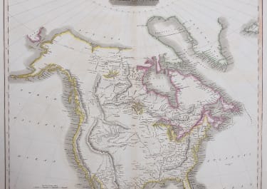
Superb map of Canada at the beginniong of the nineteenth century. From John Thomson's New General Atlas. Shows the boundary between New Brunswick and Maine as it was before the Aroostook War of 1838-39, which resulted in the present border being settled by the Webster-Ashburton Treaty of 1842.
This border had not been officially delineated at the end of the Revolutionary War, when Great Britain claimed New Brunswick as a colony. Place names are almost exclusively taken from places in Great Britain.
Thomson names Indian tribes such as the Winebagos and Ootawas, and territories such as ‘The Chippeway Hunting Area’ and the ‘Buffalo Plains’. He depicts two great forested areas, one to the east of Lake Huron and the other to the north of Lake Ontario. The Hudson Bay, the second largest bay in the world, is a huge body of saltwater with a surface area of 470,000 square miles, which dominates the upper left quadrant of the map. The intent of Great Britain to maintain holdings in the New World is obvious in names such as New Britain (the coast of Labrador).
Printed on heavy paper
Original hand colour
Excellent condition
code : M3927
Cartographer : John Thomson
Date : 1817 London
Size : 55.5*68 cms
availability : Available
Price : £225
THOMSON, John
flourised 1814-1869
John Thomson produced two major works in his life time, A New General atlas of the World 1814-28 and Atlas of Scotland 1820-32. The maps from A New General atlas of the World were printed in full hand coloring from large copperplate engravings. The level of detail at the time of publication was heralded as a breakthrough in British cartography and Thomson rightly earned a great deal of attention and his work copied for a number of years