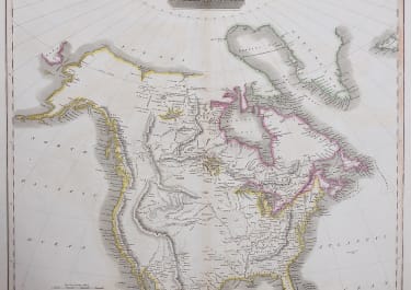
NORTH AMERICA
£245
Striking map of North America with some Lewis & Clark discoveries.
Unusual depiction of the American West based on British sources, with some of the discoveries of of Lewis & Clark. In the early 19th century, British fur traders explored the lands to the west of the Great Lakes and Hudson's Bay, mostly north of today's United States. This map contains quite good information of the lakes, rivers and some topography in this region.
It is in the United States, that Thomson depicts a very strange geography. This is to a great extent based on a late 18th century map drawn by St. Louis surveyor, Antoine Soulard, for the Spanish government. Thomson's map shows Soulard's incorrect very large "Great Bend" in the upper Missouri River, but he adds several source rivers for the Missouri, including the Madison and Jefferson. A legend along the Missouri says the mapping is based on a sketch by Captain Lewis, though the rendering is nothing like the Lewis and Clark map which would be issued the same year this map came out. The Rocky Mountains are shown essentially as a single ridge, which loops to the west to allow for the headwaters of the Missouri, and which come within a very short distance of the Pacific Coast and the Sierra Nevada Range. The lands south of the upper Missouri are essentially left blank, though the rivers and settlements of Spanish North America are shown. In the East, good information is given and throughout forts and many Indian tribes are noted. While quite inaccurate, this map by one of the leading British cartographers of the early nineteenth century shows the ignorance about the nature of the American trans-Mississippi West.
Good original colour
Very good condition for this collectors map
code : M3926
Cartographer : John Thomson
Date : 1814 London
Size : 50.5* 60 cms
availability : Available
Price : £245
THOMSON, John
flourised 1814-1869
John Thomson produced two major works in his life time, A New General atlas of the World 1814-28 and Atlas of Scotland 1820-32. The maps from A New General atlas of the World were printed in full hand coloring from large copperplate engravings. The level of detail at the time of publication was heralded as a breakthrough in British cartography and Thomson rightly earned a great deal of attention and his work copied for a number of years