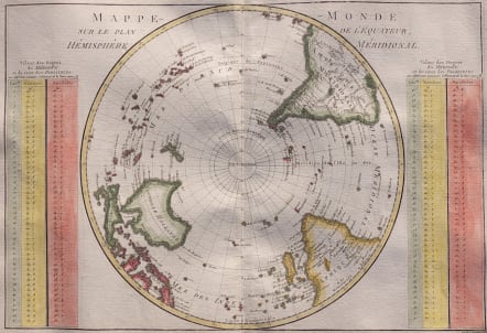
MAPPE-MONDE SUR LE PLAN DE L'EQUATEUR HEMISPHERE MERIDIONAL
Sold
Very attractive map.
South polar projection covering from the pole to the Equator. Crisply engraved to include mountain ranges and a few place names. Surrounded by two tables and a diagram. A handsome map on thick hand-laid paper with very good hand colour.
Excellent condition.
code : M3332
Cartographer : BONNE Rigobert
Date : 1780c Paris
Size : 23.5*34.5 cms
availability : Sold
Price : Sold
Rigobert Bonne (1727-1795), a prolific French cartographer, was active between about 1760 and 1788, working in the French Hydrographical Office, and appointed as Hydrographer to the French King.
Bonne prepared a large number of charts, some of which appeared in the Atlas Maritime. Today, he is best known for the smaller maps that he prepared for Raynal’s Atlas de Toutes Les Parties Connues du Globe Terrestre, published in 1780, and the Atlas Encyclopedique, published in conjunction with Nicholas Desmarest. Although the maps are relatively plain, dispensing with the decorative embellishment of mid-century, they are detailed and provide good coverage of newly discovered regions.