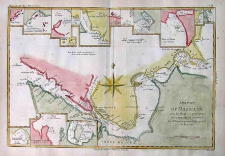
STARAITS OF MAGELLAN DETROIT DE MAGELLAN
£125
Full Title: Detroit De Magellan avec les Plans des principaux Ports, Bayes, &c. de ce Detroit . Detailed map of the Straits of Magellan from Bonne's Atlas Supplement. Shows the direction of the currents, bays, points, soundings, harbors, islands, shoals, etc. Includes the best route throught the straits, as then known in the lat 18th Century. Includes many insets of various parts of the Straits, as well as soundings and other details. Excellent hand colour.Very good condition.code : M2105
Cartographer : BONNE Rigobert
Date : 1780 Paris
Size : 24*35cms
availability : Available
Price : £125
Rigobert Bonne (1727-1795), a prolific French cartographer, was active between about 1760 and 1788, working in the French Hydrographical Office, and appointed as Hydrographer to the French King.
Bonne prepared a large number of charts, some of which appeared in the Atlas Maritime. Today, he is best known for the smaller maps that he prepared for Raynal’s Atlas de Toutes Les Parties Connues du Globe Terrestre, published in 1780, and the Atlas Encyclopedique, published in conjunction with Nicholas Desmarest. Although the maps are relatively plain, dispensing with the decorative embellishment of mid-century, they are detailed and provide good coverage of newly discovered regions.