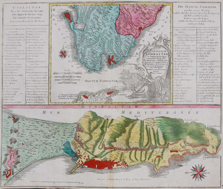
CASTELLUM GIBRALTAR IN ANDALUSIA FITUM
Sold
Antique map of the Gibraltar area in Spain, reaching from Cadiz to Marbella and across the Straits of Gibraltar to to Ceuta and Tangier. Tables of explanations in French and German to the left and right, and below a large map of Gibraltar itself (north orientated to the left) up to the lines of the Spanish siege fortifications.
Full original colour.
Couple of small worm holes repaired in margin
Very good condition in bright colour.
code : M2976
Cartographer : LOTTER Conrad
Date : 1760Augsburg
Size : 49 * 58 cms
availability : Sold
Price : Sold
The Lotter family were and engraves and publishers based in Augsburg with a prolific output of maps in the eighteenth century.
Tobias Conrad Lotter (1717-1777) worked with Georg Matthaus Seutter (his father-in-law - he married Georg's daughter in 1740) and Tobias Lobeck. In 1756 he succeeded his father-in-law jointly with Albrecht Seutter's son and Georg Balthasar Probst, also re lated by marriage. In 1758 Lotter inherited half the copperplates of the Seutter firm and was able to set up his own, independent publishing house that same year. Some of his best known atlas works are the "Atlas Minor" (c.1744), the "Atlas Der Ganzen Welt" (1748) and the "Atlas Novus" (c.1770), as well as numerous, important, single map - the "REcens Edita Totius Novi Belgica" of c.1760 being just one of note.
The Seutter/Lotter collaboration was recognised as one of the great German publishing endeavours of the eighteenth century.
Tobias Conrad was succeeded by his sons Matthaus Albrecht Lotter and Georg Friedrich Lotter, and other family members were also involved.