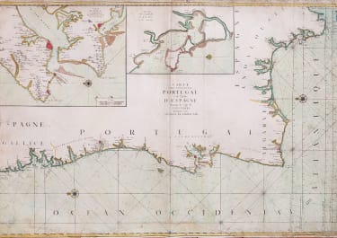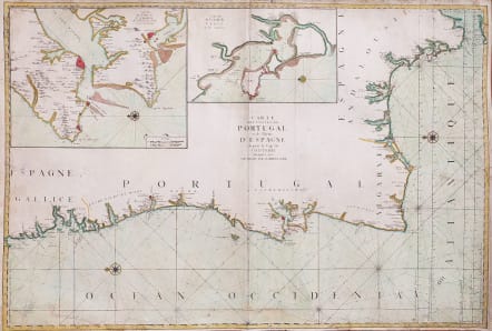
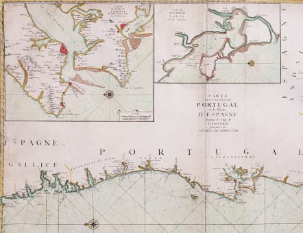
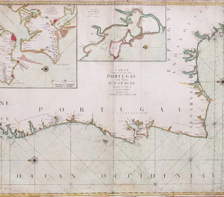
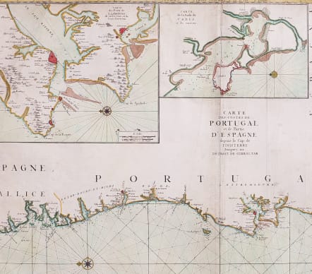
CARTE DES COSTES DE PORTUGAL ET DE PARTIE D'ESPAGNE DEPUIS LE CAP DE FINISTERE JUSQUE S AU DETROIT DE GIBRALTER
£395
Scarce map.
Stunning large-scale chart depicts the coastline of Portugal from the Strait of Gibraltar to Muros and Fisterra (Finisterre) in Spain. Key cities and river inlets are depicted along the coast, with numerous soundings, rocks, shoals, and anchorages shown. Decorative compass roses orient north to the left of the chart.
Two large insets show Lisbon with the entrance to the Tejo River and Cadiz.
Engraved by Hermann van Loon.
This map issued by Jaillot icirca in Sanson & Jaillots monumental Sea Atlas.
Heavy, watermarked paper with some repairs, extended on bottom with some manuscript, repaired tears, some slight staining on what was probably a single sheet issued map.
Good hand outline and wash colour .
Although map has its faults it is a large attractive map in reasonable condition and would look spectacular framed
code : M5619
Cartographer : JAILLOT & COLLABORATORS
Date : 1693
Size : 60*88 cms
availability : Available
Price : £395
JAILLOT and reissues
Alexis Hubert Jaillot (c.1632-1712). In 1664 he married Jeanne Berey, the daughter of Nicolas Berey, the map publisher, and following the death of his father-in-law and his brother-in-law (also Nicolas), the business passed to Jaillot and he was to gain access to much of the stock.
On the death of Nicolas Sanson, his firm passed to his sons Guillaume and Adrien. They took Alexis Hubert Jaillot into partnership in 1671, now well-established at 'Aux Deux Globes', and he was to become second only to Sanson himself among the early school of French cartographers.
A number of Sanson's maps had been prepared but never published and others were in need of revision, so Jaillot began the process of preparing new maps on larger plates. These were published in the "Atlas Nouveau", published from 1681 onwards, although individual maps date from 1672.
After the break-up of his partnership with the Sansons, Jaillot joined with the Amsterdam publisher Pierre Mortier, who engraved virtually identical copies of these large maps, re-issued from 1692 onwards. In a similar vein, Mortier also copied the maps from Jaillot's "Atlas Francois" to be re-issued by him in the "Atlas Royal".
These Jaillot atlases, both in the French and Dutch versions, mark the end of the dominance of the flamboyant Dutch school of cartography, which was superseded by the more scientifically based French school. Jaillot exemplified the scientific approach of the French school, which was to reach full maturity in the next century under Guillaume de l'Isle and his heirs, and Jean Baptist d'Anville, who established France as the centre of European cartography.