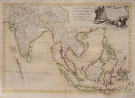
LES INDES ORIENTALES ET LEUR ARCHIPEL
Sold
Scarce map of the India, Southeast Asia, the Straits of Malaca, Philippines, Sumatra, Java, etc. extending north to the Isle of Formosa, Canton and Macao, from Jean Lattre's Atlas Moderne. Decorative allegorical cartouche showing the region as a place of commerce.
Although accredited to Bonne in the cartouche this map is a totally reengraved map by Janvier but based on Bonne"s geography.
Original outline colour
Mint good condition.
code : M3315
Cartographer : BONNE Rigobert
Date : 1762 Paris
Size : 33*46 cms
availability : Sold
Price : Sold
Rigobert Bonne (1727-1795), a prolific French cartographer, was active between about 1760 and 1788, working in the French Hydrographical Office, and appointed as Hydrographer to the French King.
Bonne prepared a large number of charts, some of which appeared in the Atlas Maritime. Today, he is best known for the smaller maps that he prepared for Raynal’s Atlas de Toutes Les Parties Connues du Globe Terrestre, published in 1780, and the Atlas Encyclopedique, published in conjunction with Nicholas Desmarest. Although the maps are relatively plain, dispensing with the decorative embellishment of mid-century, they are detailed and provide good coverage of newly discovered regions.