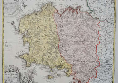
MAGNAE BRITANNIAE PARS MERIDIONALIS IN QUA REGNUM ANGLIAE
£135
Stunning detailed map
The map is based upon Visscher's map of 1695 delineating counties and showing the boundaries of the seven Anglo-Saxon kingdoms. The map is decorated by a beautiful cartouche surrounded by angels and the British coat of arms. Two other angels hold the Welsh armorial shield and at bottom is a large vignette of the King holding court. The map is densely engraved with detail including roads.
Original block colour
Decorative cartouche
Good condition
code : M5249
Cartographer : Homann
Date : 1720c Nuremberg
Size : 58*48.5 cms sheet 63*53 cms
availability : Available
Price : £135
The Family HOMANN
Johann Baptist Homann (1664-1724) started his career in Amsterdam as an apprentice with the Danckerts family before returning to Nuremberg to establish himself in business in 1702. The firm quickly became the principal geographical publishers in Germany and in 1715 Homann was appointed Geographer to the Holy Roman Emperor and he was also a member of the Prussian Royal Academy of Sciences. His publications included the “Neuer Atlas Ueber Die Gantze Welt ...” in 1707-. The “Grosser Atlas ...” of 1716- and the “Atlas Novus Terrarum Orbis Imperioa” in c.1720, as well as many others. Johann died in 1724 and was succeeded by his son Johann Christoph who died in 1730. After his death the firm took the name Homann’s Heirs and continued thereafter until 1813. Publications with the Homann’s Heirs’ imprint included the “Grosser Atlas” in 1731, Doppelmays’r “Atlas Coelestis ...” in 1742 and the “Atlas Geographicus Maior ...” in 1753-, amongst others. Throughout this entire period the firm were the leading map publishers in Germany, employing a number of very important cartographers