

PLANIGLOBII TERRESTRIS MAPPE MONDE
£995
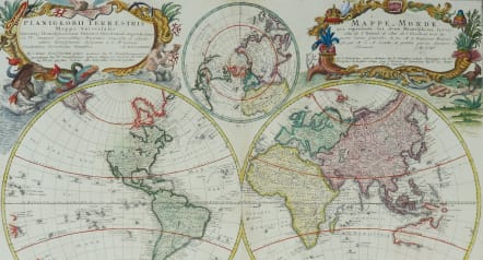
Title: Planiglobii Terrestris Mappa Universalis utrumque Hemisphaerium Orient et Occidentale Repraesentans ex IV. Mappis Generalibus ... / Mappe-Monde qui Represente les Deux Hemispheres Savoir celui de l'Orient et celui de l'Occident ...
Excudentibus Homanianis Heredibus C.P. S.C.M A. MDCCCCCCVI.
Attractive Word map in double hemisphere. In center two smaller hemispheres of the north and south pole are shown.
Two interesting diagrams depict the earth as it would be seen from space. North America is still blank above California and Hudson Bay is open-ended in the north-west corner.
Very decorative title cartouches in upper left hand right hand corner containing the titles, one in Latin and the other French.
Printed on heavy paper
A few small closed tears in margins
Original colour with later colour on carouches as Homann maps didnt usually have coloured cartouches.
Overall very good condition
References: Wagner - p. 332 #556
From: Grosser Atlas. Nürnberg, c. 1757.
code : M5289
Cartographer : Homann
Date : 1746 Nuremberg
Size : 46.5* 55 cms Sheet 51*59 cms
availability : Available
Price : £995
The Family HOMANN
Johann Baptist Homann (1664-1724) started his career in Amsterdam as an apprentice with the Danckerts family before returning to Nuremberg to establish himself in business in 1702. The firm quickly became the principal geographical publishers in Germany and in 1715 Homann was appointed Geographer to the Holy Roman Emperor and he was also a member of the Prussian Royal Academy of Sciences. His publications included the “Neuer Atlas Ueber Die Gantze Welt ...” in 1707-. The “Grosser Atlas ...” of 1716- and the “Atlas Novus Terrarum Orbis Imperioa” in c.1720, as well as many others. Johann died in 1724 and was succeeded by his son Johann Christoph who died in 1730. After his death the firm took the name Homann’s Heirs and continued thereafter until 1813. Publications with the Homann’s Heirs’ imprint included the “Grosser Atlas” in 1731, Doppelmays’r “Atlas Coelestis ...” in 1742 and the “Atlas Geographicus Maior ...” in 1753-, amongst others. Throughout this entire period the firm were the leading map publishers in Germany, employing a number of very important cartographers