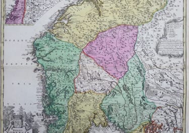
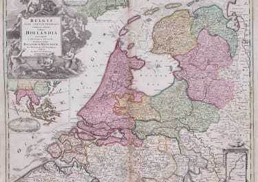
HOLLAND BELGII PARS SEPTENTRIONALIS VULGO HOLLANDIAE
£225
Interesting map of Holland celebrating it's Colonial breadth.
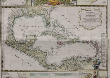
Original old coloured map of the Low Countries by JB Homann. With large inset maps of the Northeastern US from the Chesapeake to Massachusetts and Southeast Asia and additional vignette views of New Amsterdam (New York) and Batavia (Jakarta).
A very detailed map of the Low Countries, celebrating the Dutch Colonial controls over the northeastern US with New York and Southeast Asia.
Decorated with a large allegorical cartouche.
One of Homann's earliest maps and the only Homann map to include a view of New York City. (Early pre Cum Priviligio )
Centre fold with minor discolouration in part. No repairs etc good margins
Original colour
Good condition
code : M5216
Cartographer : Homann
Date : 1710c Nurembertg
Size : 48.5*57cms
availability : Available
Price : £225
The Family HOMANN
Johann Baptist Homann (1664-1724) started his career in Amsterdam as an apprentice with the Danckerts family before returning to Nuremberg to establish himself in business in 1702. The firm quickly became the principal geographical publishers in Germany and in 1715 Homann was appointed Geographer to the Holy Roman Emperor and he was also a member of the Prussian Royal Academy of Sciences. His publications included the “Neuer Atlas Ueber Die Gantze Welt ...” in 1707-. The “Grosser Atlas ...” of 1716- and the “Atlas Novus Terrarum Orbis Imperioa” in c.1720, as well as many others. Johann died in 1724 and was succeeded by his son Johann Christoph who died in 1730. After his death the firm took the name Homann’s Heirs and continued thereafter until 1813. Publications with the Homann’s Heirs’ imprint included the “Grosser Atlas” in 1731, Doppelmays’r “Atlas Coelestis ...” in 1742 and the “Atlas Geographicus Maior ...” in 1753-, amongst others. Throughout this entire period the firm were the leading map publishers in Germany, employing a number of very important cartographers