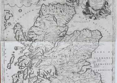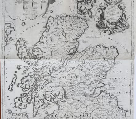


SCOTIA PARTE SETTENTRIONALE PARTE MERIDIONALE
£785
Coronelli's stunning large two sheets professionally joined map of Scotland.
Fine copper engraving in Coronelli's unique style. Inset list of Scottish counties.
Four highly decorative large cartouches with Putti, hunting dogs, heraldic shields etc.
Dedication to the theologist Tommaso Maria Peire.
One of the most decorative large format maps of Scotland from the 17th Century. The detail shows mountains, lochs, rivers, islands, bays, towns and churches.
Uncoloured as issued.
Near mint with no discolouration on centre folds often found on Corenelli's maps.
Superb map
From: Atlante Veneto. Tomo I. Venice, 1690-97. (Shirley (Brit.Lib.), T.CORO-8a)
code : M4973
Cartographer : CORONELLI Vincenzo Maria
Date : 1690 Venice
Size : 90*63 cms
availability : Available
Price : £785
Vincenzo Maria Coronelli (1650-1718) is widely recognised as one of Italy's most famous and greatest cartographers
Coronelli constructed two globes for the Duke of Parma and their success insured an invitation to Paris where he was to construct another, very large-scale (some fifteen feet in diameter) pair of globes for Louis XIV
In 1680 Coronelli also founded the oldest surviving geographical society - the Academia Cosmografica degli Argonauti.
As 'Map-maker Royal' to Louis XIV, Coronelli was based in Paris from 1681 to 1683. Here he had access to the latest French manuscript records, which he incorporated into his printed maps. Coronelli also published numbers of important maps in conjunction with the French publisher, Jean Baptiste Nolin. Nolin had engraved a set of celestial globe gores for Coronelli in 1688 and went on to become the French publisher of Coronelli's maps
Coronelli also published the Atlante Veneto (1691-1696), which was intended as a continuation of the Blaeu Atlas Maior. This vast work comprised some thirteen volumes and a wealth of information. Lists were included of ancient and modern geographers along with astronomical, geographical, historical and ecclesiastical detail. The maps from the Atlante Veneto are engraved in characteristic fine bold style, using the latest geographical information available. Many of the more important maps were engraved on two sheets, to allow greater detail.