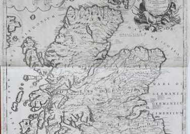
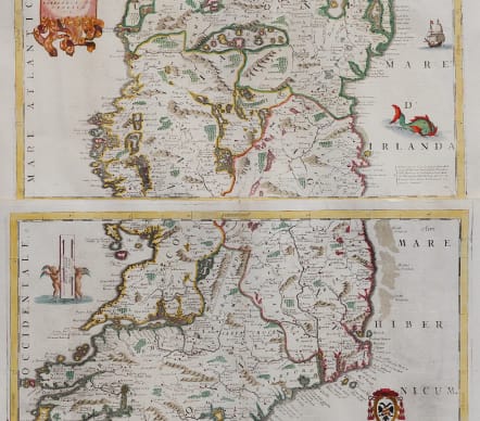


PARTE SETTENTRIONALE DELL IRLANDA IRLANDA PARTE MERIDIONALE
£1200
[ Ireland ] Parte settentrionale dell'Irlanda Descritta . . . (and) Parte Meridionale dell'Irlanda Descritta, e Dedicata Dal P. Coronelli, Cosmografo della Serenissima Republica á Monsignore Illustriss. e Reumo Badoer, Patriarca di Venetia, etc.
Superb 2 sheet map of Ireland by Coronelli , one of the most attractive and sought after maps of Ireland. Coronelli's map of Ireland, appeared in his Atlante Veneto. The map is cartographically similar to the details present in Coronelli's famous globe of 1688.
Highly decorative with large cartouches naval vessel and a sea monster.
Two sheets can be framed seperately or can be joined to make a stunning wall map.
Collector / Library / Museum quality map.
Excellent professional hand colouring
Mint condition
Ref Bonar Law:38i
code : M5101
Cartographer : CORONELLI Vincenzo Maria
Date : 1690 Venice
Size : 89*62 cms joined each sheet 46*62 cms
availability : Available
Price : £1200
Vincenzo Maria Coronelli (1650-1718) is widely recognised as one of Italy's most famous and greatest cartographers
Coronelli constructed two globes for the Duke of Parma and their success insured an invitation to Paris where he was to construct another, very large-scale (some fifteen feet in diameter) pair of globes for Louis XIV
In 1680 Coronelli also founded the oldest surviving geographical society - the Academia Cosmografica degli Argonauti.
As 'Map-maker Royal' to Louis XIV, Coronelli was based in Paris from 1681 to 1683. Here he had access to the latest French manuscript records, which he incorporated into his printed maps. Coronelli also published numbers of important maps in conjunction with the French publisher, Jean Baptiste Nolin. Nolin had engraved a set of celestial globe gores for Coronelli in 1688 and went on to become the French publisher of Coronelli's maps
Coronelli also published the Atlante Veneto (1691-1696), which was intended as a continuation of the Blaeu Atlas Maior. This vast work comprised some thirteen volumes and a wealth of information. Lists were included of ancient and modern geographers along with astronomical, geographical, historical and ecclesiastical detail. The maps from the Atlante Veneto are engraved in characteristic fine bold style, using the latest geographical information available. Many of the more important maps were engraved on two sheets, to allow greater detail.