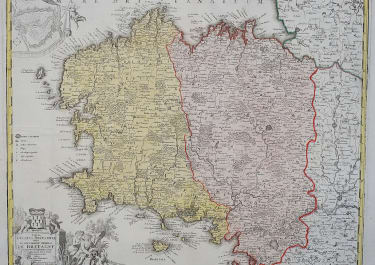
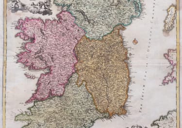
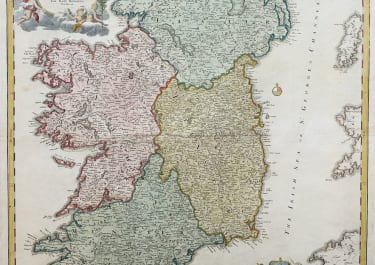
HIBERNIAE REGNUM
£350
A fine example of Homann's work, this map bears all of the distinctive hallmarks of Homann's style.
The prototype of this map was drawn in 1689 by the Amsterdam cartographer Nicholas Visscher II, who Homann credits in the title cartouche. Visscher's map became the model for most future maps of Ireland well into the late 18th century.
Homann revised and updated this map.
Ireland is divided into its four provinces, Munster, Connought (Connacht), Leinster (Lenister) and Ulster, then subdivided into numerous counties. Roads, mountains, forests, swamps, rivers, lakes, bridges towns, and even some offshore details are noted.
Elaborate title cartouche in the upper right with Gaelic iconography, including the Gaelic Harp and allegorical representations of Pan, a Celtic adaptation of the Roman god Bacchus, and Brigit, the Celtic goddess of poetry, healing and agriculture.
Another Distance bar cartouche in the lower right with four fisherman pulling in the day's haul,. Above this cartouche is the royal crest of the United Kingdom, who at the time laid claim to Ireland.
A couple of light brown marks one in map.
Excellent strong original colour
Very good condition.
code : M4818
Cartographer : Homann
Date : 1720 Nuremberg
Size : 57.5*49 cms
availability : Available
Price : £350
The Family HOMANN
Johann Baptist Homann (1664-1724) started his career in Amsterdam as an apprentice with the Danckerts family before returning to Nuremberg to establish himself in business in 1702. The firm quickly became the principal geographical publishers in Germany and in 1715 Homann was appointed Geographer to the Holy Roman Emperor and he was also a member of the Prussian Royal Academy of Sciences. His publications included the “Neuer Atlas Ueber Die Gantze Welt ...” in 1707-. The “Grosser Atlas ...” of 1716- and the “Atlas Novus Terrarum Orbis Imperioa” in c.1720, as well as many others. Johann died in 1724 and was succeeded by his son Johann Christoph who died in 1730. After his death the firm took the name Homann’s Heirs and continued thereafter until 1813. Publications with the Homann’s Heirs’ imprint included the “Grosser Atlas” in 1731, Doppelmays’r “Atlas Coelestis ...” in 1742 and the “Atlas Geographicus Maior ...” in 1753-, amongst others. Throughout this entire period the firm were the leading map publishers in Germany, employing a number of very important cartographers