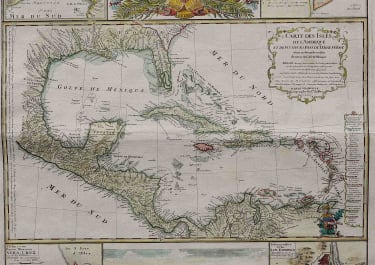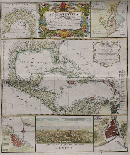
WEST INDIES, FLORIDA, MEXICO MAPPA GEOGRAPHICA COMPLECTENS INDIAE OCCIDENTALIS
£695
Very attractive & one of my favourite maps of West Indies Mexico etc.
This informative and very graphic folio sheet has a large map of the region, titled "Carte des Isles de l'Amerique et Deplusieurs Pays de Terre Ferme," attributed to D'Anville (1731). It covers the Gulf of Mexico, Central America and all of the Caribbean islands. It is nicely detailed with a key to show European possessions and a beautifully engraved title cartouche. Above the main map is the large, decorative title cartouche, flanked by insets of the isthmus of Panama and a plan of St. Augustine in Florida. Below the map is a large view of Mexico City, flanked by plans of Vera Cruz and San Domingo. A very handsome sheet, absolutely filled with information on the West Indies.
Excellent hand colour.
Mint condition.
code : M3119
Cartographer : Homann
Date : 1740 Nuremberg
Size : 48*58 cms
availability : Available
Price : £695
The Family HOMANN
Johann Baptist Homann (1664-1724) started his career in Amsterdam as an apprentice with the Danckerts family before returning to Nuremberg to establish himself in business in 1702. The firm quickly became the principal geographical publishers in Germany and in 1715 Homann was appointed Geographer to the Holy Roman Emperor and he was also a member of the Prussian Royal Academy of Sciences. His publications included the “Neuer Atlas Ueber Die Gantze Welt ...” in 1707-. The “Grosser Atlas ...” of 1716- and the “Atlas Novus Terrarum Orbis Imperioa” in c.1720, as well as many others. Johann died in 1724 and was succeeded by his son Johann Christoph who died in 1730. After his death the firm took the name Homann’s Heirs and continued thereafter until 1813. Publications with the Homann’s Heirs’ imprint included the “Grosser Atlas” in 1731, Doppelmays’r “Atlas Coelestis ...” in 1742 and the “Atlas Geographicus Maior ...” in 1753-, amongst others. Throughout this entire period the firm were the leading map publishers in Germany, employing a number of very important cartographers