CARTE REDUITE DE LA MER MEDITERRANEE
Sold
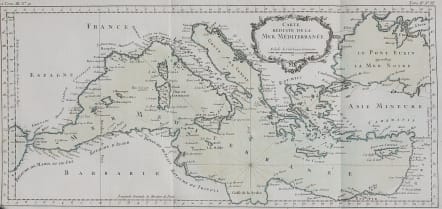
Attractive and rare map of the Mediterranean stretches from the Strait of Gibraltar in the west to the coast of Syria in the east, and includes the majority of the Black Sea. The map focuses on the islands in the Mediterranean and names coastal towns without much inland detail, with the exception of the Appenini mountain range in Italy. One set of rhumb lines radiates from the southern portion of the sea, with a simple fleur de lys pointing north. The map also features a decorative, floral title cartouche.
Original wash colour..rare...wide margins
Mint Condition
code : M3248
Cartographer : Jacques-Nicolas BELLIN
Date : 1764 Paris
Size : 24*51 cms
availability : Sold
Price : Sold
Jacques-Nicolas Bellin (1703-1772) was one of the most important and prolific French cartographers of the mid-eighteenth century, in the service of the French Hydrographical Office. He was appointed the first Ingenieur Hydrographe de la Marine, and also Official Hydrographer to the French King.
Bellin was responsible for an enormous output of charts and maps. In a large folio format, he issued a volume of sea-charts of France, the Neptune Francois, and several sea-atlases of the World, including the Atlas Maritime and the Hydrographie Francaise. These large charts were amongst the best of the period and continued being reissued throughout the second half of the eighteenth century.
In smaller format, he issued the Petit Atlas Maritime (1764),which contained 580 detailed charts, as well as maps to illustrate l'Abbe Prevost's Histoire Generale des Voyages (1746-1757). Bellin also produced a substantial number of important separately issued maps, particularly reflecting continuing discoveries and political events in the Americas.


