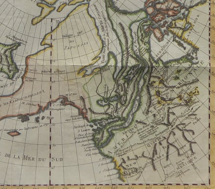
CARTE GENERALE DES DECOUVERTES DE L'AMIRAL FONTE REPRESENTANT LA GRANDE POSSIBILITE D'UN PASSAGE AU NORD OUEST PAR T. JEFFERYS
£195
Interesting map of the North American north west , showing the 'probablity of a North West passage.
The map is from the supplement to the Diderot and d'Alembert Encyclopaedie, 1772. This map of arctic America and the Bering Strait concentrates on illustrating Admiral de Fonte's claim to the existence of a Northwest Passage, here leading to Baffin Bay and Davis Strait. Alaska is shown as a peninsula rather than the group of islands so often mapped.
Excellent hand colour
Very good condition
code : M4159
Cartographer : VAUGONDY ROBERT DE Family
Date : 1772 Paris
Size : 29*36 cms
availability : Available
Price : £195
The Robert de Vaugondy family responsible for map and globe publishing in Paris comprised Gilles Robert de Vaugondy (1688-1766) and Didier Robert de Vaugondy (1723-1786). The father (Gilles) and son (Didier) business flourished from 1731 to 1778.
Prominent at this time among French map-makers were the Robert de Vaugondy family, who made a substantial contribution to the eighteenth century world of cartography, through the breadth and success of their prolific output, which included atlases, maps, globes and book illustration.
While only a small part of their output, the "Atlas Universel" encapsulates the diligent and scientific approach adopted by the Roberts de Vaugondy, and proved to be the most successful French world atlas of the period. It appeared from c.1757 onwards.