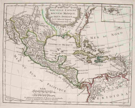
MEXICO,FLORIDA,WEST INDIES NOUVELLE ESPAGNE NOUVELLE MEXIQUE ISLES ANTILLES
£195
Map of the 18th century Spanish territories of New Spain and New Mexico together with islands of the Caribbean. Accurate coastlines and good delineation of the rivers along the Texas coast. Named cities include Taos, Albuquerque and Santa Fe in New Mexico, and St. Augustine and Pensacola in Florida. Florida has mountains, and in contrast with earlier, more accurate representations, its southern tip is split up into a group of islands. Baja California is shown as a peninsula, but its width is exaggerated. The map includes an inset of the Azores next to attractive etched cartouche by Arrivet.Original outline colour,Mint condition.code : M1555
Cartographer : VAUGONDY ROBERT DE Family
Date : 1778 Paris
Size : 25*32cms
availability : Available
Price : £195
The Robert de Vaugondy family responsible for map and globe publishing in Paris comprised Gilles Robert de Vaugondy (1688-1766) and Didier Robert de Vaugondy (1723-1786). The father (Gilles) and son (Didier) business flourished from 1731 to 1778.
Prominent at this time among French map-makers were the Robert de Vaugondy family, who made a substantial contribution to the eighteenth century world of cartography, through the breadth and success of their prolific output, which included atlases, maps, globes and book illustration.
While only a small part of their output, the "Atlas Universel" encapsulates the diligent and scientific approach adopted by the Roberts de Vaugondy, and proved to be the most successful French world atlas of the period. It appeared from c.1757 onwards.