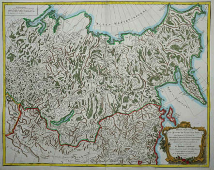
PARTIE ORIENTALE DE L'EMPIRE DE RUSSIE EN ASIE..
£195
A very attractive and detailed map of eastern Russia that was published in the "Atlas Universel". The map extends from Kamchatka to Obskaya Guba and included Lake Baikal. Detail extends southwards to include part of Mongolia and the Gobi Desert. The title appears in a decorative surround at lower left and at upper right there is a note in French explaining that the projection of this map will not support a scale. very good original outline colour with added later wash colour.
Very good condition
code : M3088
Cartographer : VAUGONDY ROBERT DE Family
Date : 1750 Paris
Size : 47*58 cms
availability : Available
Price : £195
The Robert de Vaugondy family responsible for map and globe publishing in Paris comprised Gilles Robert de Vaugondy (1688-1766) and Didier Robert de Vaugondy (1723-1786). The father (Gilles) and son (Didier) business flourished from 1731 to 1778.
Prominent at this time among French map-makers were the Robert de Vaugondy family, who made a substantial contribution to the eighteenth century world of cartography, through the breadth and success of their prolific output, which included atlases, maps, globes and book illustration.
While only a small part of their output, the "Atlas Universel" encapsulates the diligent and scientific approach adopted by the Roberts de Vaugondy, and proved to be the most successful French world atlas of the period. It appeared from c.1757 onwards.