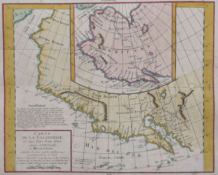
CALIFORNIA CARTE DE LA CALIFORNIE ET DES PAYS NORD OUEST
£135
Interesting study in the comparative cartography of the West Coast of North America, from the Straits of Anian to Cabo San Lucas and the southern tip of Baja California.
The work consists of extracts from two maps, both reportedly done by Visscher in the 1612 and 1641 respectively and with information derived from Mercator and Plancius. The larger map prominently shows the Strait of Anian, Anian Regnum, Quivira Regnum, the Sierra Nevada, Nova Albion, Tontonteac Regnum, Tolm Regnum and a coastal detail which includes over 30 coastal place names, including Mendocino, San Miguel (San Diego), Cape Fortuna, I. De Paxaros (Catalina?), and many mythical/ephemeral place names.
The smaller map also shows the Straits of Anian, but depicts an open sea above, clearly portending a NW Passage in the Arctic Circle. The NW Coastline differs radically, and only Anian Regnum and Quivira Regnum are located, that later considerably south of the location on the larger map. The smaller map includes a similar number of coastal placenames, but includes several important ones not listed on the larger map, including C. Blanco (3 times), C. de San Francisco and los Farilones, but ommits any significant effort to depict bays.
Folds as issued. Small repairs and supported by archival paper., Otherwise good condition.
code : M2761
Cartographer : VAUGONDY ROBERT DE Family
Date : 1772 Paris
Size : 30*36 cms
availability : Available
Price : £135
The Robert de Vaugondy family responsible for map and globe publishing in Paris comprised Gilles Robert de Vaugondy (1688-1766) and Didier Robert de Vaugondy (1723-1786). The father (Gilles) and son (Didier) business flourished from 1731 to 1778.
Prominent at this time among French map-makers were the Robert de Vaugondy family, who made a substantial contribution to the eighteenth century world of cartography, through the breadth and success of their prolific output, which included atlases, maps, globes and book illustration.
While only a small part of their output, the "Atlas Universel" encapsulates the diligent and scientific approach adopted by the Roberts de Vaugondy, and proved to be the most successful French world atlas of the period. It appeared from c.1757 onwards.


