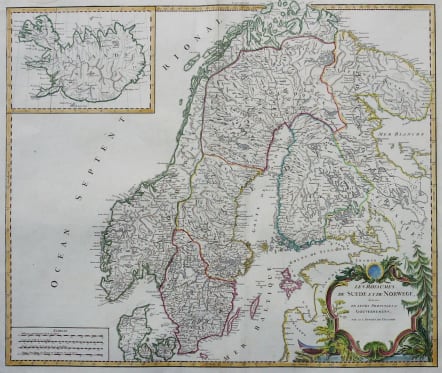
LES ROYAUMES DE SUEDE ET DE NORVEGE
£250
Attractive large format map of Scandinavia, published in De Vaugondy's Atlas Universel, one of the most successful lt French atlases of the 18th Century. Very detailed map. Large decorative cartouche.Original outline colour with added later colour.
Very good condition.
Large inset of Iceland. Decorative cartouche.
code : M2863
Cartographer : VAUGONDY ROBERT DE Family
Date : 1756 Paris
Size : 49*58.5 cms
availability : Available
Price : £250
The Robert de Vaugondy family responsible for map and globe publishing in Paris comprised Gilles Robert de Vaugondy (1688-1766) and Didier Robert de Vaugondy (1723-1786). The father (Gilles) and son (Didier) business flourished from 1731 to 1778.
Prominent at this time among French map-makers were the Robert de Vaugondy family, who made a substantial contribution to the eighteenth century world of cartography, through the breadth and success of their prolific output, which included atlases, maps, globes and book illustration.
While only a small part of their output, the "Atlas Universel" encapsulates the diligent and scientific approach adopted by the Roberts de Vaugondy, and proved to be the most successful French world atlas of the period. It appeared from c.1757 onwards.