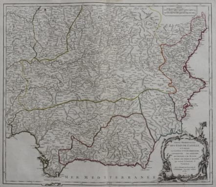
Partie Meridionale des Etats de Castille, ou se trouvent la Castille Nlle., l'Estremadure, l'Andalousie, les Royaumes de Grenade et de Murcie; et partie des Etats d'Aagon, qui contient le Royaume de Valence.
£150
Attractive and very detailed map of that part of Southern Spain that covers Granada, Gibralter, Malaga , Deville and Valencia. Decorative cartouche.Original outline colour.
Very good condition.
Reference:
Pedley. Belle et utile, p.185 no. 312.
code : M2830
Cartographer : VAUGONDY ROBERT DE Family
Date : 1757 Paris
Size : 48*55 cms
availability : Available
Price : £150
The Robert de Vaugondy family responsible for map and globe publishing in Paris comprised Gilles Robert de Vaugondy (1688-1766) and Didier Robert de Vaugondy (1723-1786). The father (Gilles) and son (Didier) business flourished from 1731 to 1778.
Prominent at this time among French map-makers were the Robert de Vaugondy family, who made a substantial contribution to the eighteenth century world of cartography, through the breadth and success of their prolific output, which included atlases, maps, globes and book illustration.
While only a small part of their output, the "Atlas Universel" encapsulates the diligent and scientific approach adopted by the Roberts de Vaugondy, and proved to be the most successful French world atlas of the period. It appeared from c.1757 onwards.