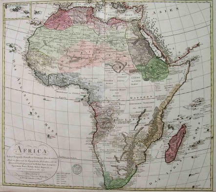
AFRICA BASED ON VAUGONDY
£250
Rare large map of the Continent.
BY Schneider, Adam Gottlieb 1745-1815. L'AFRICA nach Robert Vaugondy, Rennell's und Solzmann's Skizze des nord lichen Theils von Africa... Nurnberg Schneider and Weigel 1794.
Very interesting and rare map of the whole of Africa at the end of the eighteenth century.Colour coded possessions.Full original colour.Bootom margin reinforced.Very good condition.
Notes: Norwich Map 111. From: "Atlas der Geographie von der bekannten ganzen welt...
Subjects, general: Africa--Maps--Early works to 1800.
Early Map AMS7549
code : M2041
Cartographer : VAUGONDY ROBERT DE Family
Date : 1794 Nremberg
Size : 52 x 58.5 cm.
availability : Available
Price : £250
The Robert de Vaugondy family responsible for map and globe publishing in Paris comprised Gilles Robert de Vaugondy (1688-1766) and Didier Robert de Vaugondy (1723-1786). The father (Gilles) and son (Didier) business flourished from 1731 to 1778.
Prominent at this time among French map-makers were the Robert de Vaugondy family, who made a substantial contribution to the eighteenth century world of cartography, through the breadth and success of their prolific output, which included atlases, maps, globes and book illustration.
While only a small part of their output, the "Atlas Universel" encapsulates the diligent and scientific approach adopted by the Roberts de Vaugondy, and proved to be the most successful French world atlas of the period. It appeared from c.1757 onwards.


