


CARTE REDUITE DES PARTIES SEPTENTRIONALE DU GLOBE SITUEES ENTRE L'ASIE ET L'AMERIQUE
Sold
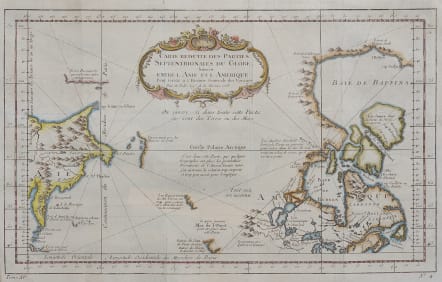
Very unusual chart showing only the northeast coastline of Canada with Baffin and Hudson Bay and the St. Laurence River. On the other side is the northeast coastline of Asia with the Kamchatka peninsula. In between are a few small areas of coastline with notations concerning reported explorations, including those of Juan de Fuca, the Russian expedition in 1728 and 1741, the reported Sea of the West and the English quests for a Northwest Passage.
Good hand colour
Very good condition for this collectors map
code : M4512
Cartographer : Jacques-Nicolas BELLIN
Date : 1777 Paris
Size : 21*34.5 cms
availability : Sold
Price : Sold
Jacques-Nicolas Bellin (1703-1772) was one of the most important and prolific French cartographers of the mid-eighteenth century, in the service of the French Hydrographical Office. He was appointed the first Ingenieur Hydrographe de la Marine, and also Official Hydrographer to the French King.
Bellin was responsible for an enormous output of charts and maps. In a large folio format, he issued a volume of sea-charts of France, the Neptune Francois, and several sea-atlases of the World, including the Atlas Maritime and the Hydrographie Francaise. These large charts were amongst the best of the period and continued being reissued throughout the second half of the eighteenth century.
In smaller format, he issued the Petit Atlas Maritime (1764),which contained 580 detailed charts, as well as maps to illustrate l'Abbe Prevost's Histoire Generale des Voyages (1746-1757). Bellin also produced a substantial number of important separately issued maps, particularly reflecting continuing discoveries and political events in the Americas.


