WORLD ESSAY D'UNE CARTE REDUITE CONTENANTLES PARTIES CONNUEES DE GLOBE TERRESTE
Sold
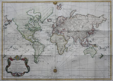
Bellin's famous large planisphere world map.
This very large and attractive world chart is drawn on Mercator's projection. North America is shown with a prominent River of the West connecting through a series of rivers and lakes from Lake Superior to the Pacific - representing the elusive search for a Northwest Passage. The Russian discoveries in the North Pacific are shown with Alaska depicted as an island named I. Unamak. Australia is labeled Nouvelle Hollande with Terre de Diemen still linked to the mainland. New Zealand is fully formed showing both islands and there are numerous islands in the Pacific. The large, decorative title cartouche and two fine compass roses with rhumb lines make this a very attractive chart. Australia and New Zealand reflect the discoveries of Capt. Cook, but Tasmania is still attached to Australia, suggesting a publish date after 1770.
Good hand colour.
Folds flattened.
Very good condition.
code : M2726
Cartographer : Jacques-Nicolas BELLIN
Date : 1775 Paris
Size : 52*71 cms
availability : Sold
Price : Sold
Jacques-Nicolas Bellin (1703-1772) was one of the most important and prolific French cartographers of the mid-eighteenth century, in the service of the French Hydrographical Office. He was appointed the first Ingenieur Hydrographe de la Marine, and also Official Hydrographer to the French King.
Bellin was responsible for an enormous output of charts and maps. In a large folio format, he issued a volume of sea-charts of France, the Neptune Francois, and several sea-atlases of the World, including the Atlas Maritime and the Hydrographie Francaise. These large charts were amongst the best of the period and continued being reissued throughout the second half of the eighteenth century.
In smaller format, he issued the Petit Atlas Maritime (1764),which contained 580 detailed charts, as well as maps to illustrate l'Abbe Prevost's Histoire Generale des Voyages (1746-1757). Bellin also produced a substantial number of important separately issued maps, particularly reflecting continuing discoveries and political events in the Americas.


