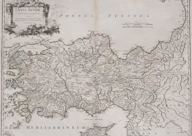
ASIA MINOR
£135
Title: ASIA MINOR in suas partes seu provincias divisa, auctore ROBERT DE VAUGONDY Geog. Regis, et Academiae Scientiarum ac Litterarum Nanceianne Socio, Cum privilegio Regis 1756
Interesting copperplate engraved map includes Asia Minor between the Bosporus Strait and the Caucasus, and from the Black Sea to the Mediterranean (including Cyprus). It shows a bewildering mix of historic and contemporary place names and political organization, with trade routes (both modern and ancient) noted in hashed lines. Pictorial relief gives little indication of the rugged and varied regional topography.
A decorative cartouche in the upper left includes many elements of Classical Antiquity; including a weapons, armor, and an amphora. A burning city can be seen faintly in the background, perhaps a reference to the fall of Constantinople to the Ottoman Empire in 1453. The holy city and former Roman capital was still under Turkish control at the time of publication in the mid-18th century, and had long been coveted by Christian monarchs across Europe.
Very good condition
code : M5380
Cartographer : VAUGONDY ROBERT DE Family
Date : 1756 Paris
Size : 49*62 cms
availability : Available
Price : £135
The Robert de Vaugondy family responsible for map and globe publishing in Paris comprised Gilles Robert de Vaugondy (1688-1766) and Didier Robert de Vaugondy (1723-1786). The father (Gilles) and son (Didier) business flourished from 1731 to 1778.
Prominent at this time among French map-makers were the Robert de Vaugondy family, who made a substantial contribution to the eighteenth century world of cartography, through the breadth and success of their prolific output, which included atlases, maps, globes and book illustration.
While only a small part of their output, the "Atlas Universel" encapsulates the diligent and scientific approach adopted by the Roberts de Vaugondy, and proved to be the most successful French world atlas of the period. It appeared from c.1757 onwards.