
OCCIDENTALIOR TRACTUS INDIARUM ORIENTALIUM
Sold
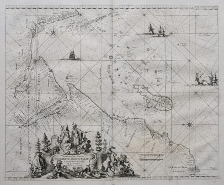
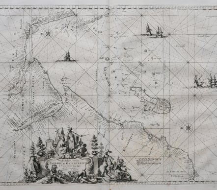
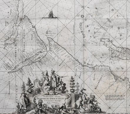
Stunning example of Frederic De Wit's sea chart of Africa, Arabia and part of India. This map, here the one in the rare 1745 edition by Reiner & Joshua Ottens, is also a testament to the pinnacle of Dutch engraving, skillfully brought to life by the hands of the esteemed Romeyn De Hooghe.
This sea chart, adorned with compass roses and rhumb lines, meticulously detailing coastlines, islands, and navigational intricacies. From the Cape of Good Hope to Cape Comorin, the map gracefully unveils the contours of the Arabian Peninsula, the Red Sea, and the Persian Gulf. Madagascar and a scattering of islands extending to the Maldives are depicted with exceptional precision, underscoring the navigational possibilities of the vast Indian Ocean.
This map serves as a practical guide, illuminating the maritime route for European traders venturing toward the East Indies. Its detailing of navigational routes and coastal features marks it as an indispensable companion on the seafaring journey, embodying the fusion of artistry and utility in the world of cartography.
Mint condition
From R. & J. Ottens' sea atlas Atlas van Zeevaart published in 1745. The map first appeared in atlases by F. de Wit, later also by L. Renard.
code : M5499
Cartographer : ANON
Date : 1745 Amsterdam
Size : 44*53.5 cms sheet size 54*63 cms
availability : Sold
Price : Sold