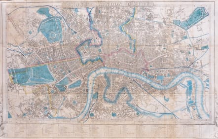


CROSS'S LONDON GUIDE
£395
Folding map of London. Taken from directory and folds flattened. Rare in that it is printed on linen. Hand coloured.
Originally Printed 1837 and 4 reprints finally this edition.
Title set in top border. Explanation of colours and imprint set in bottom border. No date on map.
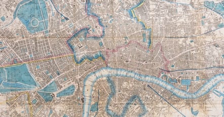
Map divided into half mile squares and margins lettered and numbered for reference. References to Public Buildings, Exhibitions &c., Theatres, Police Offices, and Miscellaneous Buildings below bottom margin.
Maps printed on linen or silk were very useful in that the were not subject to the vagaries of weather. But they were more expensive to produce.
Decorative motifs at corners. Original colour
Very good condition.
Its principal interest lies in its detailing of the expansion of the railways. London's first railway was opened in 1836, running between Bermondsey and Deptford, reducing the average travelling time from an hour to eight minutes. This line was extended to Greenwich and London Bridge, with the extension recorded on the map. By 1841 there were six terminal stations in London, with railways linking London with Birmingham and Southampton. These terminals were set at a distance from the centre of the city, due to fears of street congestion. This map shows the Great Western, Birmingham, Eastern Counties, Blackwall, Southampton and Croydon railways.
REF Howgego No. 360 (4)
code : M5019
Cartographer : ANON
Date : 1855 London
Size : 44*68 cms
availability : Available
Price : £395