


CONSTANTINOPLE PLAN DE LA VILLE DE CONSTANTINOPLE ET DE SES FAUBERGS
£695
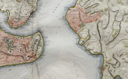
Very rare large plan of Constantinople by Fr Kauffer and Le Chevalier.
This uncommon plan was made specifically for Le Comte De Choisseul-Gouffier French Ambassador to the Ottoman Empire. It was made from a bew survey by Kauffer & Le Chevalier much more detailed than any previous plan of the City / Cities. The plan shows in detail the Cities on the East side of the Bosphorus .. Kadikoy etc. The Cities if Galata & Pera on the northern side of the Golden Horn.
It details every street and important building,water depths etc.Typical of French cartography of this period for its precision coupled with superb design.. Kauffer was a Turkish engineer in the service of the Sublime Porte at Istanbul, who surveyed the area 1776-1782.
Jean Baptiste LeChevalier was a French astronomer, art historian, archaeologist, librarian, writer and cartographer.
This map was a benchmark for maps of Constantinople for the best part of the next hundred years.
Good later hand colour
Very good condition
* An essential map of collectors of Constantinople maps and the Ottoman Empire.
Ref: https://commons.m.wikimedia.org/wiki/File:Plan_de_la_ville_de_Constantinople_et_de_ses_faubourgs,_tant_en_Europe_qu%27en_Asie_-_lev%C3%A9_g%C3%A9om%C3%A9triquement_en_1776_par_Fr._Kauffer_;_v%C3%A9rifi%C3%A9_et_augment%C3%A9_en_1786_par_le_m%C3%AAme_Fr._Kauffer_et_par_M._Le_Chevalier_-_btv1b53027654c.jpg
code : M5355
Cartographer : ANON
Date : 1786 Paris
Size : 47.5*67cms
availability : Available
Price : £695