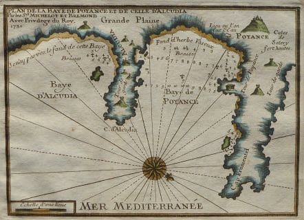
PLAN DE LA BAYE DE POYANCE ET DE CELLE D'ALCUDIA
Sold
Scarce chart of the bays of Poyance (Pollensa or Pollenca) and Alcudia with Cap Fromentel (Formentor) on the island of Mallorca (Majorca). The villages of Alcudia and Poyance are shown. With several towers, composition of beaches, anchorages, and soundings are noted along with a water source.
This plan was produced ca. 1730 by French hydrographer and pilot of the French royal galley "La Reale" Henry Michelot. The port plan was one of 37 original plans published in Marseilles by Michelot and Laurens Bremond in a volume titled "Recueil de Plusieurs Plans de Ports et Rades de la Mer Mediterranée."
Good later hand colour
Very good condition
code : M4150
Cartographer : ANON
Date : 1730 Marseille
Size : 18* 25.5 cms
availability : Sold
Price : Sold