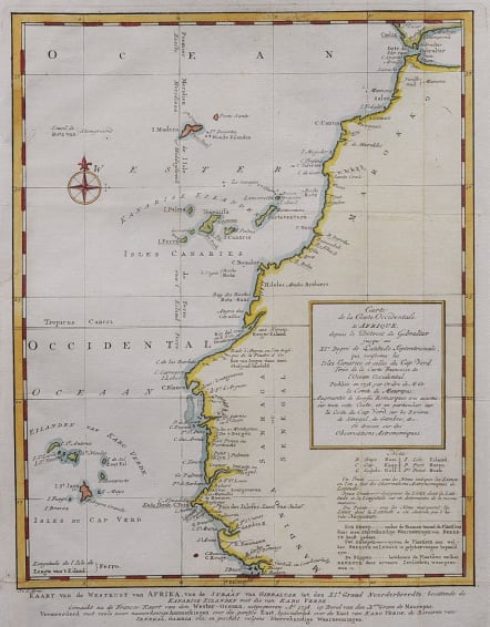
CARTE DE LA COSTE OCCIDENTALE D'AFRIQUE
£70
Coste Occidentale D'Afrique, Depuis le Détroit de Gibraltar Jusqu'au XI.e Degré de Latitude Septentrionale : Tirée de la Carte de l'Ocean Occidental, Publiée Par Ordre de MGR. le Comte De Maurepas en 1738.
Good early Dutch printing, later issued by Bellin.
"West Coast of Africa, From the Strait of Gibraltar Until the 11th Degree of Northern Latitude. From the Map of the Western Ocean Published By Order of Mgr. the Count of Maurepas in 1738."
Map of the western coast of Africa, including present-day Morocco, Western Sahara, Mauritania, Senegal, the Gambia, and Guinea-Bissau; includes the Canary Isles, Madiera and Cap Verde Isles.
Good hand colour
Good condition
code : M5561
Cartographer : ANON
Date : 1738 Paris
Size : 26.5*20.5 cms sheet 30*23 cms
availability : Available
Price : £70