A MAPP OF THE PARISH OF ST MARTINS IN THE FIELDS TAKEN FROM YE LAST SURVEY WITH ADDITIONS
Sold
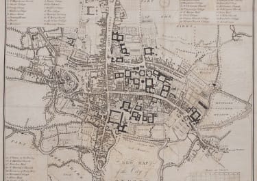
Attractive map of St Martins-in-the-fields parish, along with the new buildings belonging to the parish around Hanover Square.
This includes much of the West End and Covent Garden. The main thoroughfares shown include The Strand, Haymarket & Long Acre. The maps stretches from Whitehall at the bottom to Drury Lane at the top. Charing Cross and the King's News are shown on the present site of Trafalgar Square. Other streets marked inclide Scotland Yard, 'Leicester Fields' . Inset, the "new buildings belonging to St Martin's Parish" shown around Hanover Square, south of the "Tiborn Road" (Oxford Street) include Bond Street and Conduit Street.
Excellent hand colour
Very good condition
code : M4700
Cartographer : ANON
Date : 1720 London
Size : 37.5*31.5 cms
availability : Sold
Price : Sold