


CARTE DES PARTIES NORD ET OUEST DE L'AMERIQUE
Sold
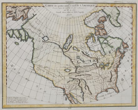
Important and detailed map of North America shows both east and west coasts, as well as Canada & Alaska.
California & the Pacific Northwest coast to Alaska is still speculative & uncharted, whereas the east coast is depicted from Newfoundland, Nova Scotia & New England down to Florida and the Gulf Coast, showing Boston, Pennsylvania, Maryland, Virginia and Georgia.
Place names and names /location of Indian tribes. No sign of Rockies alargely fictitious interior.
Fascinating map of North America, based upon a map by Thomas Engel.
Engel's map of North America was issued in his Memoires Observations Geographiques in 1765, and provides a fascinating look at the water courses across North America, with no less than 4 rivers reaching from the Pacific to the Rocky Mountains and one nearly to the Mississippi, commencing near Puget Sound. Baron La Hontan's mythical River of the West is shown with only a short portage from L. de Tahuglanks across the Rockies to the source of the Mississippi. Two other rivers begin north of the Bering Strait and feed the mythical Lake Conibas popularized by Wytfliet in 1597, with Lake Michinipi, passing over top of the Rockies.
Printed for Diderot's Encyclopedia Usual folds from book
Good hand colour ..
Very good condition
Ref Wheat 158, Pedley 453, Portinaro 158.
code : M4040
Cartographer : VAUGONDY ROBERT DE Family
Date : 1772 Paris
Size : 30*38.5 cms
availability : Sold
Price : Sold
The Robert de Vaugondy family responsible for map and globe publishing in Paris comprised Gilles Robert de Vaugondy (1688-1766) and Didier Robert de Vaugondy (1723-1786). The father (Gilles) and son (Didier) business flourished from 1731 to 1778.
Prominent at this time among French map-makers were the Robert de Vaugondy family, who made a substantial contribution to the eighteenth century world of cartography, through the breadth and success of their prolific output, which included atlases, maps, globes and book illustration.
While only a small part of their output, the "Atlas Universel" encapsulates the diligent and scientific approach adopted by the Roberts de Vaugondy, and proved to be the most successful French world atlas of the period. It appeared from c.1757 onwards.


