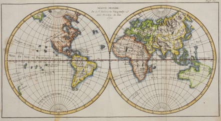
MAPPE MONDE PAR ROBERT DE VAUGONDY..1750
Sold
Small charming double hemisphere world with a blank western coastline of North America and partially mapped Australia and New Zealand. Good hand colour
Flattened folds
From: Methode Abregee et facile pour apprendre la Geographie
V Good condition.
Ref
Ref: Pedley #7.
code : M3333
Cartographer : VAUGONDY ROBERT DE Family
Date : 1750 Paris
Size : 15*28 cms
availability : Sold
Price : Sold
The Robert de Vaugondy family responsible for map and globe publishing in Paris comprised Gilles Robert de Vaugondy (1688-1766) and Didier Robert de Vaugondy (1723-1786). The father (Gilles) and son (Didier) business flourished from 1731 to 1778.
Prominent at this time among French map-makers were the Robert de Vaugondy family, who made a substantial contribution to the eighteenth century world of cartography, through the breadth and success of their prolific output, which included atlases, maps, globes and book illustration.
While only a small part of their output, the "Atlas Universel" encapsulates the diligent and scientific approach adopted by the Roberts de Vaugondy, and proved to be the most successful French world atlas of the period. It appeared from c.1757 onwards.


